Martin Frobisher
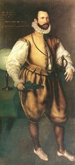
Vowing "to make a sacrifice unto God of his life rather than return home without the discovery of Cathay" the notorious Elizabethan privateer Martin Frobisher ventured forth from his native England in command of a three ship flotilla of brave, or uninformed, mariners in 1576. Frobisher was on a quest to discover the elusive Northwest Passage – to navigate a seaway around the inconveniently located North America and open the wealth of the Orient to English merchants. According to Michael Lok, Frobisher's financial backer, it was a grandly altruistic scheme: the voyage would reveal the secret sea route, "to yield to the Queen's Majesty great honor, and to the whole realm infinite treasure."
To daring seafarers and privateers of Elizabethan England the discovery of the Northwest Passage offered glory, wealth and prestige equal to, or greater than, the plunder of Spanish galleons in the South Seas; it also offered cruel hardships, and perhaps death. It was the great geographical prize, a metaphor for the aspirations of an optimistic and expanding nation. England would benefit immensely from locating a safe sea route to Asia, breaking the Spanish and Portuguese monopoly of the Pacific and African routes. If the theory of the open polar sea was correct, the Northwest Passage would not only be free from interlopers, it would also be much shorter.
Frobisher's first foray to the frozen north was a small affair. Having little knowledge yet fantastic expectations, he sailed in two small vessels, approximately 25 tons each, and a small pinnace too insignificant to be given a name. Only one of the ships, however, survived the turbulent violent storms of the Atlantic crossing without difficulty. The other vessel returned damaged to England, and the pinnace was sucked to its doom beneath the frigid waves. In spite of this inauspicious beginning, Frobisher forged forward into Meta Incognita, searching for the Northwest Passage. He believed he had found it when he sailed into what is today known as Frobisher Bay on the southern tip of Baffin Island. George Best, the chronographer of Frobisher's first voyage, boldly pronounced: "So this place he named Frobisher's Straights, like as Magellan at the southwest end of the world, we having discovered the passage to the south sea." It was Frobisher's belief that the land on his left as he sailed west through the 'Straight' was the main continent of North America while the land on his right was none other than Asia.
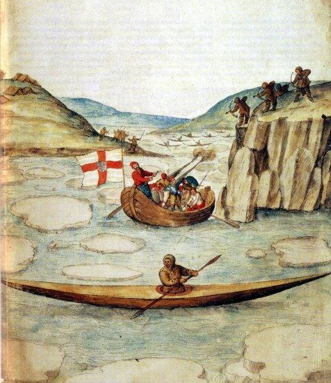
Although it was barren, windswept, rocky and cold, Frobisher's Asia was not a deserted land; nor did it resemble the fabled civilization of the great Khan, famous from the writings of Marco Polo. The explorers encountered Inuit peoples dwelling along the shore and, believing them to be Asians, perhaps from a remote northern province, immediately captured one who ventured too close. Stowing their human cargo, they continued their journey 180 kilometers along the 'Straight' (presumably far enough to prove it was not an inlet) before departing the desolate land for England. They were cheerfully welcomed when they arrived in London in the fall along with their captured "Strange man of Cathay."
Michael Lok paraded and displayed the man and his boat (as well as many other souvenirs that had been brought back from the 'Orient') around London and the surrounding countryside. Flowers and grass and other foreign plants were among some of the items proudly displayed. Most importantly, however, a small black stone was returned. This stone, according to Humphrey Gilbert in 'Discourse of a Discovery for a New Passage to Cathaia', "glistered with a bright marquesset of gold" when held near to a fire.
When an unscrupulous Italian assayer, Jean Baptiste Agnello, identified the substance as gold, the Northwest Passage was promptly forgotten and the Cathay Company was hastily formed–with the prime objective of garnering the golden nuggets from Baffin Island. Frobisher, a pragmatic man, did not make a sacrifice to God of his life, as he earlier had pronounced. Instead, he outfitted a second naval expedition and departed for the Arctic in 1577.
Exploration was not on Frobisher's agenda. Any lingering thoughts he had of following his strait through to the Orient were immediately forgotten in the haste to profit from the undefended gold. His ships were not loaded with diplomats, merchants and trade goods; rather, they carried a cargo of over 150 Cornish miners and heavy equipment for a serious excavation. To Frobisher, and perhaps to most of England, the only interest in exploration was to discover a source of wealth to rival what the Spanish had found when they conquered the peoples of Central and South America. "Asia" held no intrinsic value to Frobisher other than as a source of treasure, to be exploited for personal and national profit. Regardless of whether he still believed he had reached the shores of the fabled Orient, a huge mountain of gold ready for the taking was just as good.
After a summer season of heavy work (but no further exploration into Frobisher Bay) Frobisher returned from Baffin Island with 200 tons of black lumpy ore, the so called 'gold' of "Frobisher's Straights." The expedition received a jubilant welcome as they lumbered up the Thames into London. For his patriotic service Frobisher was awarded the lofty title of 'High Admiral of Cathay'. Master Dionise Settle (the chronographer of this second expedition), perhaps unswayed by Frobisher's dubious boastings, foreshadowed the future with his prophetic pronouncement that: "the stones of this supposed continent with America be altogether sparkled, and glister in the Sunne like gold: so likewise doth the sand in the bright water, yet they verifie the old Proverb: All is not gold that glistereth." Disregarding Dionise Settle's warning, Frobisher again sailed for Baffin Island in 1578 – before the true nature of the black ore could be determined. The 'High Admiral' captained a fleet of 15 ships, the largest to assemble in the North Atlantic until World War II. The ships were loaded with over 300 miners with heavy mining equipment and had provisions for the first permanent English colony in North America.
En route to Baffin Island, a portion of the cumbersome fleet was blown off course and was caught in a swirling, turbulent stream of water south of the mine site. After navigating the churning channel for a while Frobisher determined that he had missed his original landing. He named the inlet (likely Hudson Strait) the "Mistaken Straights" and headed east and north to continue his mining (again, Frobisher didn't bother to truly explore the region, nor did he try to accurately document his discovery for future expeditions). Then a violent storm ground and pummeled the fleet, sinking many of the supply ships before they had reached the mine site. Plans for the new colony were indefinitely postponed, while the remaining vessels continued with the all-important mining operation. Another (staggering) quantity of black ore was hauled back to England; a quantity which, according to George Best, would "reasonably suffice all the gold gluttons of the world."
It was disgrace and not a hero's welcome which awaited the haggard survivors of the voyage. During their absence it was determined that absolutely no gold could be alchemized from any of the ore returned the previous year–the 'Asian' gold was worthless. (Eventually some of the gravel was used to pave London streets, while the remainder was shoveled into the Thames). The Cathay Company was bankrupt, Frobisher was publicly humiliated and English exploration in the Arctic was abandoned for a decade, until John Davis again ventured north in 1585.
Frobisher, more a brash adventurer than a meticulous explorer, left no personal journal nor charts of his voyages (at least none has been uncovered). The little documentation of his voyages that exists was written by other mariners in his crew and contains few geographical notations or observations. The chronographers on these voyages were less concerned with accurately charting their location, than with recording the expedition's daily occurrences and detailing Frobisher's bravery and strength. John Davis, for example, although theoretically aware of Frobisher's voyages, likely had no idea he was anywhere near Frobisher's mine site when he explored the east coast of Baffin Island south past Frobisher Bay (without entering it) and into Hudson Strait.
Undoubtedly, 16th century cartographers, basing their charts on a healthy mixture of first hand observation and optimistic speculation, had a difficult job piecing the scraps of geographical knowledge together to accurately chart this very confusing region–a region which is the nexus of numerous inlets, bays, channels and straits. Another source of confusion was the erroneous depiction of the fantastical Friesland on the Zeno map, an error perpetuated by Gerhard Mercator on his famous charts. One can almost imagine the poor cartographers poring over vague and misleading journals, trying to reconcile recorded land sightings and observations with accepted charts which showed extra islands in the North Atlantic. If cartographers were tracing Frobisher's journey (from whatever accounts of the voyage existed at the time) they would have mistaken his Greenland sighting for Friesland and hence Baffin Island for Greenland.
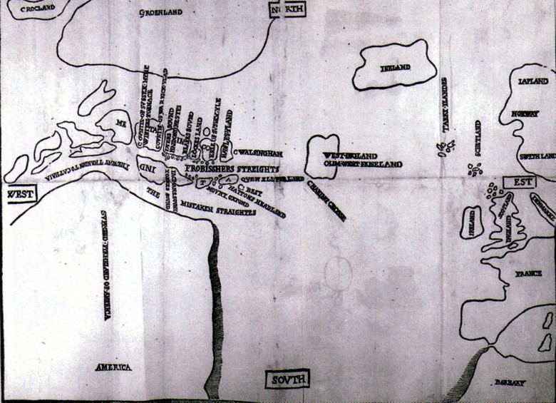
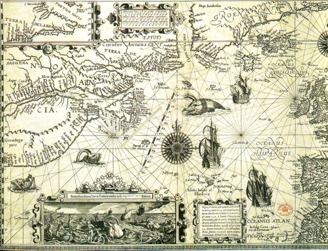
The map of North America engraved by Jan van Doetecom in 1594, for example, clearly shows Sr Martin Forbosshirs Straijtes dissecting the southern tip of Greenland (where it remained for over two centuries) and continuing as an inlet on the west side of Davis Strait (Fretum Davis). The inset in the upper left hand corner, however, was perhaps based on a different source: where Frobisher's Strait is clumsily depicted on the main map, the inset shows A furious over fall (commonly associated with Hudson Strait), and above it L. Lumley's Inlet approximately where Frobisher Bay would appear on a modern map. The inset is strikingly similar to a portion of Gerhard Mercator's 1595 Chart of the North Pole.
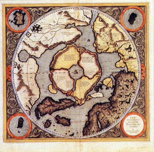
Mercator's polar projection, which clearly reflects the explorations of John Davis, also shows Frobisher Strait on the southwestern tip of Greenland, and L. Lumley's Inlet just north of a furious over fall on Baffin Island. Once it made its way onto Mercator's influential chart, other cartographers likely copied it, having no reason to doubt his sources. Sanson d'Abbeville's chart of Le Canada ou Nouvelle France (1656) shows Destroit de Forbisher carving through southern Greenland and entering into Davis Strait. And Samuel Dunn's A Map of the British Empire in North America (1776) has it vaguely sketched in as False Frobisher's Straights, while what appears to be the modern Frobisher Bay is shown as an inlet on the southern portion of the Isle of Good Fortune (Baffin Island).
Perhaps successive generations of cartographers continued to place the strait conveniently out of the way, where it wouldn't interfere with the better documented discoveries of other, more important, explorers. In either case, the actual location of Frobisher's strait was of little political or economic significance after John Davis, Henry Hudson (1610), and William Baffin (1624) had successively revealed the true complexity of eastern Arctic geography, and Hudson Bay became the focus for English commercial interests during the 18th century. By the late 18th century cartographers likely suspected that Frobisher's strait was not in southern Greenland, but they had no conclusive evidence to justify a relocation, and no compelling reason to initiate a further search.
On John Cary's A New Map of North America. From the Latest Authorities (1811) there is no strait through southern Greenland. Frobisher's Str has crossed Davis Strait and appears in place of Lumley's Inlet on the as yet unnamed Baffin Island. And it is shown inconclusively as either a strait, an inlet or a bay. The relocation was probably based on educated speculation–retracing Frobisher's route as recorded in the travel accounts of his chronographers, without the mythical Friesland in the way. Although by the early 19th century, cartographers had generally placed the 'Straight' in the correct region and had accurately charted all the nearby inlets and waterways, it was not until the 1860's that the mystery was solved.
The American explorer Charles Francis Hall, while searching for clues to the lost Franklin expedition in 1860, was stranded near the shore (of what was still known as Frobisher Strait, on Baffin Island) by a violent storm which damaged the whaling ship he had traveled on. After listening to the oral history of the local Inuit, Hall was able to locate the site of an earlier expedition. On and surrounding Kodlunarn Island, he uncovered the remains of a mining pit, the foundations of a stone house as well as shards of pottery, glass, coal and tiles which he suspected were the remnants of Frobisher's 16th century mining operation. It was the first evidence of Frobisher's expedition to be unearthed. It was also final proof that Frobisher Strait, although correctly positioned, was not a strait after all, but a bay.
Over a century later, in 1974, an archaeological expedition headed by the Royal Ontario Museum systematically excavated the mine site and building remains, settling any lingering doubts about Frobisher's destination and activities in the New World. (A chemical analysis of Baffin Island ore found near the mine site revealed it to contain large quantities of biotite mica-fool's gold, and Frobisher was the fool.)
Confirming the location of "Frobisher's Straights," the first of many mythical polar routes to Cathay, took almost as long as finding an actual Northwest Passage through the Arctic Archipelago. Considering the inhospitably cruel and deadly region through which Frobisher sought this passage, however, his blind quest into the unknown is as much a testament to his personal determination and optimism, as it is to the undefeatable curiosity of humanity. (Never mind that he abandoned it so quickly to pursue his golden delusions, another human trait.) Most importantly, though, it is a testament to the perseverance and scientific motivation of generations of navigators, cartographers and archaeologists that, after 300 years, they finally got it right.
Return to Stories Index Page